
Executive Summary
For generations, the Juba and Wabi Shabelle rivers have been the agricultural lifelines of southern Somalia. Today, however, a deepening crisis is taking shape along those transboundary waterways. Decades of conflict left Somalia’s institutions unable to track or respond to sweeping environmental and hydro-engineering changes beyond its borders.
- Advertisement -
Using satellite data and hydrologic modeling, the Association of Somali Agricultural Professionals (ASAP) has identified what it describes as the systematic, unilateral re-engineering of the Juba River Basin by Ethiopia. Ethiopia has a legitimate sovereign right to pursue economic development, but its reliance on large, highly consumptive infrastructure—built without transboundary consultation—has effectively disregarded the needs of its downstream neighbor. That upstream reality has rendered Somalia’s historic pre-war mega-dam ambitions obsolete and demands a fundamental shift toward domestic flood harvesting and defensive water governance.
I. Introduction: The Post-Conflict Hydro-Blindspot and the Treaty Gap
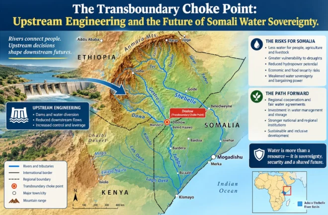
A transboundary river network ties the security of nations together across political borders. The Juba River Basin covers more than 218,000 square kilometers, with Ethiopia accounting for 67% of the basin, Somalia 28%, and Kenya 5%.
After Somalia’s central government collapsed in 1991, the country entered a prolonged era of conflict and institutional paralysis. As political leaders concentrated on domestic stabilization, the nation’s geography remained exposed. The vulnerability is compounded by a critical legal gap: Ethiopia has consistently declined to sign a binding transboundary water-sharing treaty or create a formal bilateral framework with Somalia for the Juba and Wabi Shabelle basins. With no legal obligation to provide real-time hydro-meteorological data, operating schedules for water infrastructure, or upstream basin measurements, Ethiopia retains effective control of the headwaters while Somalia remains largely uninformed.
With no diplomatic mechanism or official channel through which to monitor changes to shared water resources, Somali agricultural professionals established the Association of Somali Agricultural Professionals (ASAP) in the United States in 2018. The organization brings together Somali agricultural experts, scientists, and researchers working to advance the country’s agriculture. To address the resulting data vacuum, ASAP used satellite telemetry and advanced hydrologic modeling—simulations of how water moves across landscapes—to produce the basin’s first comprehensive spatial and flow profile in 2025. The findings exposed the downstream system’s structural vulnerabilities.
II. Hydrological Architecture of the Juba Basin
ASAP’s water-management models show why control of the Ethiopian highlands is so closely tied to southern Somalia’s economic survival. Four principal tributaries rise in the region’s high-rainfall zones and feed the Juba River: Genale 1, Genale 2, Dawa, and Gestro.
Measurements from the key Bardheere gauging station in Somalia show a pronounced imbalance in their contributions:
• Genale 1: 47% of the river’s total mean annual volume.• Dawa: 22%.• Genale 2: 21%.• Gestro: 3% of downstream flow.
3. The Evaporation Tax: Ethiopia’s decision to construct a vast, open-air reservoir in a hyper-arid climate carries a heavy evapotranspiration cost. At the GD-3 site alone, an estimated 178 million cubic meters of water disappear into the atmosphere every year—equivalent to 7% of total capacity and benefiting neither country.
adinside1By constructing highly consumptive, high-evaporation networks while refusing to sign a binding Transboundary Water-Sharing Treaty or guarantee a Minimum Environmental Base Flow, Ethiopia’s policies pose an existential danger to downstream Somali agriculture.
V. Strategic Comparisons: Intentional Mitigation vs. Deliberate Exclusion
Ethiopia’s approach also points to a stark difference in how Addis Ababa manages upstream harm affecting its downstream neighbors:
• The Kenyan Model (Intentional Mitigation): On the Omo River, Ethiopia recognized that its upstream dams would cause serious damage to Lake Turkana and nearby communities. Seeking to offset that known impact, Ethiopia offered Kenya a compensatory quid pro quo: access to its energy grid and 500 MW of inexpensive electricity. Over the past two decades, Ethiopia has also become a dominant regional hydro-engineering power. Supported by state-directed capital and international partnerships, Addis Ababa has methodically pursued master plans for the Genale-Dawa (Juba) and Wabi Shabelle basins.
The Cascading Dam Network
Ethiopia has pursued a cascading-dam strategy: a series of sequential, step-locked dams along the same river channel designed to maximize water retention and electricity generation.
• Genale-Dawa III (GD-3): Inaugurated in February 2020, the large multi-purpose concrete-faced rockfill dam has a reservoir capacity of 2,570 million cubic meters (Mm^3) and an installed generating capacity of 254 Megawatts (MW).
• GD-5 and GD-6: These planned downstream elements of the cascade are scheduled for completion by 2032 and 2029, respectively. Their storage capacities are listed at 132 Mm^3 and 183.6 Mm^3.
• Tributary Diversions: Secondary infrastructure manages smaller branches, including the 50 Mm^3 Chelchel Dam on the Gestro tributary and the Welwel project on the Mena tributary.
The Scope of Agro-Pastoral Transformation
adinside2Ethiopia’s plans call for 93 medium- and large-scale irrigation schemes covering more than 1 million hectares. The program is projected ultimately to supply municipal water and agricultural livelihoods to an estimated 15 million people in the Ethiopian sections of the basin. Because roughly 90% to 95% of the basin’s total flow originates in Ethiopia, the river is naturally highly seasonal, with the wet Gu and Dyr periods alternating with the hyper-arid Jilal and Xaga seasons.
III. The Ethiopian Blueprint: Unilateral Statecraft and Capacity
Over the past two decades, Ethiopia has transformed itself into a regional hydro-engineering power. With state-backed investment and international partnerships, Addis Ababa has advanced coordinated development plans for both the Genale-Dawa (Juba) and Wabi Shabelle basins.
ation schemes targeting over 1 million hectares of irrigated land. This framework is projected to eventually provide municipal water supply and agricultural livelihoods to an estimated 15 million people within the Ethiopian portions of the basin.
IV. Assessing “Disregard”: The Choice of High-Harm Alternatives
Ethiopia invokes the international-law principle of Equitable and Reasonable Utilization as it seeks to lift its population out of poverty. Yet the way it has implemented its plans reflects a unilateral course that bypasses lower-impact alternatives. Hydro-diplomacy experts argue that Ethiopia could have expanded economic opportunities at home while placing less pressure on Somali agriculture:
1. Consumptive Surface Irrigation vs. Groundwater: Ethiopia’s master plan depends heavily on open-air, gravity-fed surface canals. Because irrigation consumes the diverted water, much of it never returns to the river system. Ethiopia could instead have drawn on the Genale-Dawa basin’s extensive, replenishable aquifers through solar-powered drip irrigation, sharply reducing its surface-water withdrawals.
2. Mega-Reservoirs vs. Run-of-River (RoR) Power: GD-3’s huge 2,570 Mm^3 reservoir was built primarily to support hydropower generation. Ethiopia could have opted for smaller Run-of-River plants, which use the river’s natural speed to turn turbines before immediately returning 100% of the water to the channel, producing zero net reduction in downstream volume.
• The Somali Model (Deliberate Exclusion): In the Juba and Wabi Shabelle basins, Ethiopia had the same understanding that its large upstream cascade and water-intensive irrigation plans could deprive downstream Somali farms of water. Despite that awareness, it offered no compensation, mitigation, or relief. The result is a policy in which transboundary harm was softened for one neighbor but left entirely unaddressed for another.
VI. The Death of a Dream: The Baardheere Dam Project
Ethiopia’s upstream development has permanently changed Somalia’s domestic infrastructure choices, above all the country’s historic Baardheere Dam Project.
The Pre-War Vision
Conceived during the late 1970s and 1980s under the administration of Mohamed Siad Barre, the Baardheere Dam was intended to anchor Somalia’s economic independence.
• Specifications: The proposed 75-meter-high concrete dam would have created a reservoir holding 3,400 million cubic meters (Mm^3) of water.
• Objectives: The project was designed to produce 105 MW of hydropower, reducing reliance on imported diesel, and to provide permanent irrigation for 175,000 hectares of commercial farmland. Its broader aim was to turn the Juba Valley into Somalia’s national breadbasket.
The Historic Irony
adinside3During the late 1980s, Ethiopia strongly opposed Somalia’s unilateral effort to advance the Baardheere Dam. It warned international donors that a downstream dam would establish “prior use” historical rights and give Somalia an effective legal veto over future Ethiopian projects upstream. Those objections delayed World Bank financing until Somalia descended into civil war in 1990, bringing the project to a permanent halt.
Why Revitalization is Terminally Infeasible
Somalia cannot simply revive the original 1980s plans for Baardheere:
• Hydrological Starvation: A 3,400 Mm^3 reservoir would require a steady, unobstructed river supply to maintain its hydraulic head. Ethiopia’s upstream cascade can now trap and retain the river’s principal flow, making it mathematically impossible to fill the original Baardheere reservoir as designed.
• The Double-Evaporation Crisis: Storing another 3,400 Mm^3 in southern Somalia’s scorching lowlands, downstream from an already evaporating Ethiopian cascade, would produce severe cumulative losses and could completely dry the river’s lower reaches.
• The Financial Bar: International lenders follow strict transboundary policies that bar financing for a multibillion-dollar downstream mega-dam whose main water source is entirely controlled by an upstream state.
VII. Conclusions and Recommendations for Somali Leadership
The former vision of the Juba as a continuously flowing, naturally regulated river has disappeared. Even if administrative constraints inside Ethiopia slow its planned expansion to 1 million hectares of agriculture, the physical infrastructure capable of restricting, delaying, and evaporating the river is already in place.
Somali leaders and policymakers should therefore abandon 20th-century mega-dam ambitions and move immediately toward an internal, defensive water-harvesting strategy:
[Old Continuous Reliance Model] ── Upstream Control ── Downstream Dry Riverbeds[New Sovereign Retention Model] ── Internal Catchment ── Localized Small-Scale Dams
• Pivoting to Smart Regulating Barrages: Instead of pursuing massive storage capacity, Somalia should redesign the Baardheere site as a low-height, asset-light regulating barrage. Its primary role would be to absorb and stabilize irregular surges released by Ethiopia’s upstream hydropower turbines.
• Harvesting Internal Flash Floods: The government should prioritize a decentralized network of small retention dams in flood-prone regional centers inside Somalia, particularly around Beled-Hawo, Garbahaarey, Wajid, Rab Dhuure, and Ceel Boon. During the intense Gu and Dyr seasons, these structures could capture localized flash floods before the water disperses across the landscape.
By retaining these internal, seasonal climate flows, Somalia could independently recover roughly 8% of the Juba River’s historical mean annual flow. Because this localized supply would not be subject to upstream control, it could provide the water security needed to sustain Somali agriculture in the years ahead.